EU helps US with satellite imagery damage Texas
World
August 30, 2017 14:48
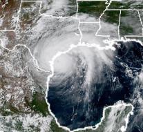
- BRUSSELS European Union is shooting the United States with satellite imagery of the ravage that hurricane Harvey has done in Texas state. The US authorities have asked for it, according to the European Commission. Using data from the European Sentinel satellites, the damage in the affected area is mapped.
The federal aid organization FEMA and the European Coordination Coordination Center are constantly in touch with the situation, says the committee. 'The EU knows how devastating natural disasters can be. The US can count on our support, 'explains EU Foreign Minister Federica Mogherini.
The satellite services are part of the Copernicus program launched in the launch of the first satellite (Sentinel-1) in 2014, a joint initiative of the European Commission and the European Space Agency ESA. It is the world's largest earth observation program.
Leave a comment