Breaking News
March 5, 2026 - Emma Hayes' Vision for USWNT at 2027 Women's World Cup Taking Shape March 5, 2026 - Manchester City Targets Gibbs-White and Anderson Dent Club's Title Hopes March 5, 2026 - Arsenal in Control of Premier League Title Race Despite Controversial Game Management March 5, 2026 - USA vs. Canada: Live Coverage of SheBelieves Cup on ESPN March 4, 2026 - Flamengo Sacks Coach Despite 4 Titles and 8-0 Win March 4, 2026 - Predicting Starting XIs for 2026 World Cup Contenders March 4, 2026 - Transfer Rumors: Manchester United, Chelsea, Liverpool Eye USMNT Star Tyler Adams March 3, 2026 - USMNT Analysis: 100 Days from the World Cup March 3, 2026 - Spain and France Top World Cup 2026 Power Rankings 100 Days Before Kickoff March 3, 2026 - Harry Kane Chases Lewandowski Record in Bundesliga Goal Tally
  • HotRecentNews.com
  • World
  • Politics
  • Sports
  • Entertainment
  • Science
  • Technology
  • Health
HotRecentNews.com
Menu
  • World

  • Politics

  • Sports

  • Entertainment

  • Science

  • Technology

  • Health

Home / World / Satellite Images Show Devastation in Mayotte Before and After Cyclone Chido

Satellite Images Show Devastation in Mayotte Before and After Cyclone Chido

Satellite Images Show Devastation in Mayotte Before and After Cyclone Chido
No Comments 20
Facebook X
World December 17, 2024 19:40

mayotte - Satellite images reveal the destruction caused by deadly cyclone Chido in Mayotte, with winds of over 220 kilometers per hour leaving a trail of death and devastation.

The intensity of the deadly cyclone Chido last Saturday on the French archipelago Mayotte can be clearly seen in satellite images. The damage is immense and the exact number of casualties is still unknown.

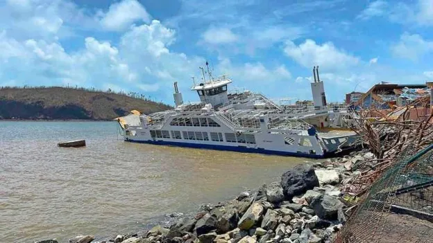
With winds gusting at over 220 kilometers per hour, the tropical cyclone Chido has brought death and destruction to Mayotte since Saturday, the small archipelago between Madagascar and Mozambique. There are fears that in the coming days and weeks, many hundreds or even thousands of people will be found dead amidst the rubble.

New satellite images from Maxar Technologies, which also showcased remarkable images of the devastation caused during the war in Ukraine, now clearly show the extent of the cyclone's impact. The images show the capital Mamoudzou, where schools, houses, hospitals, restaurants, and many other buildings have been reduced to rubble.

There are also images of the airport, the port area, and other parts of the city, all showing the devastation caused by the cyclone.

NEW TikTok Removes #SkinnyTok Worldwide After Pressure from Brussels and Paris

Leave a comment Cancel

reload

Trending Now

  • Today
  • Yesterday
  • Month
  • Comments
  • 1

    Wrexham Eyeing Andy Robertson for Premier League Promotion Bid

    March 5, 2026
  • 2

    Premier League Transfer Needs Analysis for 20 Clubs

    March 5, 2026
  • 3

    USMNT 2026 World Cup Squad Predictions for March Camp

    March 5, 2026
  • 4

    Kane and Yamal Named ESPN's Players of the Month for February

    March 5, 2026
  • 5

    Barcelona and Bayern Reign as Top European Teams in 2026

    March 5, 2026
  • 1

    'Future Socceroo' Rhys Bozinovski Joins Heracles Almelo from Perth Glory

    February 4, 2026
  • 2

    Jamaica Unveils Vibrant Kits for 2026 World Cup Playoffs

    February 13, 2026
  • 3

    Controversy at Man City vs. Newcastle Match: VAR Check and Potential Red Card Incident

    February 22, 2026
  • 4

    Sam Kerr's Career-Defining Moment: 2026 Women's Asian Cup

    February 26, 2026
  • 5

    VAR Review: Controversial Penalty and Red Card Decision in Man United vs. Crystal Palace Match

    March 1, 2026
Hot Recent News
The HOTRECENTNEWS.com is not responsible for the content of external sites.

SEARCH

  • World News

Back to Top